Archaeology
There are a number of historical features scattered through the community forest, including ancient villages, chambered cairns and even a holy well dedicated to a reclusive Saint. The location of these features can be seen by clicking on the following link:
St. Modan's Well
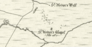
1869 map that recorded St Modan’s Well
The community forest is home to a holy well (or spring) dedicated to the 6th century Irish monk St. Modan, who rose to become the Abbot of Dryburgh Abbey. In later life, St. Modan shunned his role to become a hermit in the Dumbarton area. Located in the Clachan of Glendaruel below the well is the medieval church-site of Kilmodan, which, as its name suggests, is similarly dedicated to St Modan. It is believed that ministers and worshippers once trod a pilgrim’s path from the church to pray up at the well – perhaps to reflect on the holy man adopting a more natural lifestyle in later life. Although the well was recorded on an 1869 map as a historical feature, it was absent from later maps. However, using the old maps, the Cowal Archaeological Society were able to locate the well in the 1960s and recorded that: ‘This spring seems to have been backed by fairly large stones and 20 or 30 quartz pebbles were found’. Quartz pebbles have long been used as an expression of prayer or devotion in burials, holy wells, and prayer..
Following the introduction of commercial forestry to the area in the 1970s, the well was soon lost to the dense forest. It remained that way until 2015, when after the community had purchased and cleared the forest, a search was able to relocate the precious natural spring. Today, St Modan’s well is clearly signposted, so that visitors to the forest can once again enjoy its cool and clear waters.
Auchategan Ancient Village

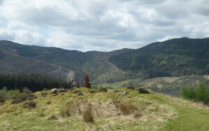
Remains of the Auchategan Settlement
The settlement of Auchategan has been in use since Neolithic times. Detailed excavations, undertaken between 1967 and 1970, initially revealed three hut circles, possibly early shielings, with nothing to date them but half a quern (a simple hand mill). Beneath the huts was found a rectangular house and under this, the post holes of an earlier rectangular hut, which was built over the site of an early bloomery or smelting hearth. Underneath the floor of the rectangular house lay a small Bronze Age cist (pronounced kist) or burial chamber, containing fragments of burnt bone. Outside the area of the house and near to the edge of the settlement site was an unusual semi-circular cairn in which was found another Bronze Age cist. When this cairn and the other later buildings were removed, two Neolithic occupation levels were revealed. Each had post holes and hearths. Among the finds were many pottery fragments, a flint knife, a flint arrowhead and two polished stone axes. Material taken from the lowest Neolithic level gave a carbon-14 dating of 2300 BC +/- 110, whilst material taken from the rectangular hut gave a date of AD 660 +/- 100.
All that remains at the settlement are the foundations of a stone-built rectangular house, measuring 5.0m x 2.4m. Elsewhere, however, the settlement was removed by the excavation 50 years ago, with all finds being handed to the National Museum of Antiquities of Scotland for cataloguing and safekeeping.
You can learn more about the Auchategan settlement from the Canmore register of historic sites:
Lephinkill Chambered Cairn
Remains of the Lephinkill Chambered Cairn
This Neolithic chambered cairn is situated 600m to the east of the Clachan of Glendaruel in a clearing within a forestry plantation; and at a height of 140m. It is similar to the chambered cairn at Ardachearanbeag, about 900m to the north. The cairn appears as an irregular heather-clad mound of stones measuring about 25m x 11m, and around 2m in height. It appears to have been disturbed over the millennia and stones have been moved to provide material for several sheep-shelters, one of which survives almost intact on the mound itself. Although carbon-dating has not been undertaken on site, Clyde-type chambered long cairns of this style are thought to have been common around 3000 BC.
The burial chamber is at the north end of the cairn and is entered through a concave facade, now partly hidden by blocking material. The eastern portal stone measuring 1.0m by 0.25m, and typical of Clyde-type long cairns, still protrudes about 0.5m above the surface of the mound. A small semi-buried stone situated behind the eastern portal and set parallel to it, might indicate a second portal. The western portal stone does not appear to have survived, but a small supporting stone behind its likely position can still be seen; measuring only 0.4m by 0.15m and protruding 0.3m. Two displaced side-slabs of the chamber are still visible, both over 0.6m in height. An excavated hollow on the line of the continuation of the chamber suggests that it was originally between 3m and 4m long overall. Parts of what are probably corbel stones can be seen overlying the fallen side-slab on the eastern side of the chamber. No human remains or artefacts were found during archaeological visits in 1976 and 1984.
Cup and Ring Marked Stone
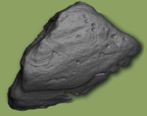
Laser analysis of the Cup & Ring Carvings
Archaeological analysis of a boulder in the lower reaches of the community forest, has found evidence of Neolithic rock carvings in the form of cup and ring marks. Such symbols are typical of the period between 4000 BC to 1800 BC, and are thought to be a form of abstract rock art, in that they are symbols as opposed to pictures. Special cameras were used to identify 10 cup engravings in total, with one surrounded by a complete ring, and another by a keyhole shaped ring. Such features would have been created using tools made of stronger rock, such as quartz, and by way of a pecking action. The true meaning of these symbols has been lost in the mists of time, but some believe they may have been used to share local information, or even be related to rituals.